October 8, 2026 · Bill · Rotor Rate · Reviewed October 4, 2026
The Anatomy of a $264 Drone Batch: Four Stops, Two Days, and the Hourly Math
I got a live one here! A four-property drone inspection batch looks like a fun day, but then you map out the route. We provide an anonymized Colorado example that shows multi-site and multi-day math, gross hourly pay, and why knowing your cost floor matters.
A job offer lands in your inbox and it reads: four properties, $264 total. Hmm, doing the quick math, that's $66 a stop. It’s certainly nothing special; it sounds like a decent little afternoon if you have the time. That’s only if you read the headline and not look behind the curtain. Once you do that, you notice the actual towns: Parker, Black Hawk, Gunnison, and Lake City, Colorado. For those outside of the state, those are not in one centralized area; rather, they're all across the state with twisty, mountain passes between a couple of them. Also of note, two of the assignments carry a “premium” label, meaning they are larger properties.
Did I laugh out loud? Yes. Yes, I did.
To protect the innocent, I removed the network, made each location the town center, and not that of the actual address of the client’s client, etc. This article is to illustrate a point and not tear into a network for questionable practices.
Put the four stops in the calculator
Here's how it went down and how I used the Multiple job sites button. I opened Rotor Rate's calculator, chose the network in question, entered the first address, and then turned on Multiple job sites, and added the remaining addresses as Sites B–D (Site A automatically populates with the initial address once you click the button). I used a generic Parker, CO home base for this example, not my address. To be honest, I gave each site one hour on site and 30 minutes of editing as that's typically what I average for this kind of work (uploads can be slow at times, so just giving myself a little breathing room). That's four hours on location and two hours of post-processing/data upload, and doesn’t include any flight planning or driving. Depending on what you charge per hour for this kind of flight and data upload, you might already be losing money on this job; if so, it’s only going to get worse. Could I shave some of the time in the calculator to "make it work"? Maybe (that's a terrible idea BTW - don't ever do this), but each site typically has something about it that adds more time than you initially allot for the job; my typical one-hour allotment includes a little buffer for those unforeseen things.
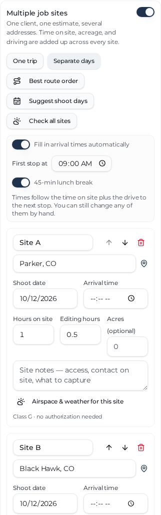
Example inputs only. These are city-level pins, not the offer's property addresses; the airspace indicators in a city-level example are not preflight clearance.
Now because the addresses are spread across the state and not local to a single location, I spread the missions over two days using the buttons rather than assuming the entire state fits into an afternoon. However, for giggles, let's break down what a one-day trip would look like and what it looks like over two days:
- All in one trip: The drive: Parker home base → all four listed sites → Parker home base. The calculator models 483.9 miles. At its assumed 55 mph average (lots of mountain driving in the mix), that's about 8.8 driving hours. Add the six hours of on-site and editing time: that comes to 14.8 working hours, or $17.84/hour at their offer of $264. Now, that's before any of your business costs, taxes, etc., get their shake at that price. Something to also take note of is that we're getting into the fall season where daylight gets less and less by the day; this will be a factor in a fifteen-hour planned trip like this.
- Separate days: Put Parker and Black Hawk on day one, Gunnison and Lake City on day two (the buttons parse it out into the most efficient routes on which days). The model increases and becomes 564.6 miles across two home-base round trips. That's roughly 10.3 driving hours, plus the six hours of on-site and editing time: about 16.3 working hours, or $16.23/hour.
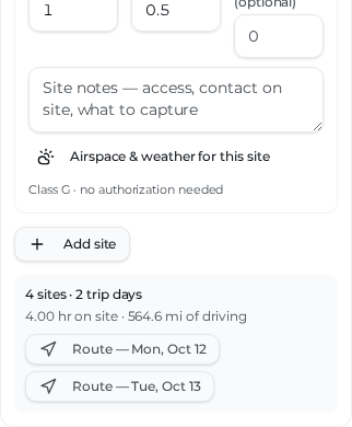
Now to the fun part: the hourly number is the part that hurts
$264 ÷ 4 properties = $66 per property. But these aren’t just four quick flights. For the two-day scenario, it's $264 ÷ (564.6mi ÷ 55/hr driving + 4hrs on-site + 2hrs editing hours) ≈ $16.23 per working hour. That isn't a wage after expenses. It doesn't include time for planning, battery changes, client messages, an overnight stay, or any weather delays. Add any one of those to the job, and the effective hourly number falls even further. Fast.
Hmm, how much is minimum wage these days? Ouch.
If you've ever said, “Well, at least I'm getting paid to fly,” yeah, I totally get it. But the drone isn't doing those hours of mountain driving for free, and neither are you. Also, of your time on site with those jobs, only a portion of it is actually flying the drone. You’ll also be snapping images of the house using your phone and walking around trying to avoid dog poop, toys, holes, wasps, you name it.
Find your floor before you send a number
So, what if you don’t know your bottom-line number? When do you cross the threshold of losing money? Don’t worry, I got you covered.
Try the free Hourly Rate Builder with your gear, insurance, software, vehicle costs, and realistic billable hours. Its Floor is your annual costs divided by billable hours: break-even, not a paycheck. Sustainable adds the take-home target and a self-employment-tax buffer. Your floor and sustainable number will differ from anyone else's. It's free and takes a few minutes to do. It’s also the most important number you need to know about your business (never go below your floor, you're losing money if you do).
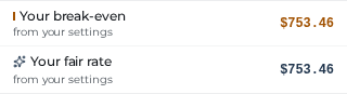
With this walkthrough's illustrative in-app settings (including a $125/hour fly rate, $50/hour travel rate, vehicle getting 25 mpg, and $3.94/gallon fuel - haha, we can only wish for sub $4/gal now); the two-day calculator shows $753.46 for both “Your break-even” and “Your fair rate” because no local industry benchmark was loaded. That isn't a universal fair market price; it is the calculator's settings-derived result for these example inputs. The bottom line and take-away is, the $264 offer is $489.46 short of the numbers we put in for this illustration.
So what do you do with an offer like this?
There are several options; you can counter with a number that covers the scope, ask whether the four sites can be split among local pilots, or pass. If you're already near one of the stops or the scope is lighter than this example assumes, your economics might be different. That's why we recommend running your route and your floor instead of just declaring a blanket price for everyone (which is very typical on social media when asking ‘how much should I charge?).’
I won't pretend to know what the network intended here; the fuel alone for the trip was almost half of the total offer. But when pilots price only the flight and forget the windshield time, taxes, break-even costs, etc., those thin margin jobs can become the norm. A lot of unknowing pilots end up working a whole lot of hours for not much of a living, get burned out and leave the industry. Don't be that person, you don't have to absorb that gap.
Next time a batch looks like easy money, put the actual addresses and the dates in the calculator first. Try the multi site and multi day buttons to figure out the most efficient use of your time. Let the hourly number have the last word.
Until next time.
Bill
Sources and method
- IRS standard mileage rates — check the rate for your actual trip dates and eligibility with your tax professional; January–June 2026 was 72.5¢/mile, July–December is 76¢/mile.
- Rotor Rate Hourly Rate Builder — annual costs, target take-home, and billable-hours methodology.
- Route screenshots and figures: Rotor Rate calculator, city-level Colorado pins, Parker, CO example home base; four hours on site, two editing hours; October 12–13, 2026 example shoot dates. No actual property addresses or real user settings are shown.
Related guides
Go deeper on the rest of the drone-pricing topic — same framework, different angle.
Swipe for 4 links →
How to Price Drone Services
The eight factors and bid formula behind every defensible quote.
Drone Photography Pricing hub
Real-estate, brand, and event photo rate ranges with the math behind each.
Drone Mapping Pricing hub
Per-acre rates, processing time, and how to tier large-area jobs.
Drone Inspection Pricing hub
Tower, roof, solar, and infrastructure inspection rate ranges.
Next steps
What to do once you have a number you trust.
Swipe for 2 links →