Rotor Rate: drone pricing and job-management software for Part 107 commercial drone pilots — quote profitably, track mileage and expenses, estimate quarterly taxes.
Mission management, smart pricing, auto mileage, expense tracking, and quarterly tax estimates — all in one place.
- Mission management: track jobs from pending → awarded → completed
- Auto mileage logging & expense capture for tax season
- Quarterly tax estimates based on actual mission profit
- Pricing across photo, mapping, inspection, LiDAR, BIM & digital twin work
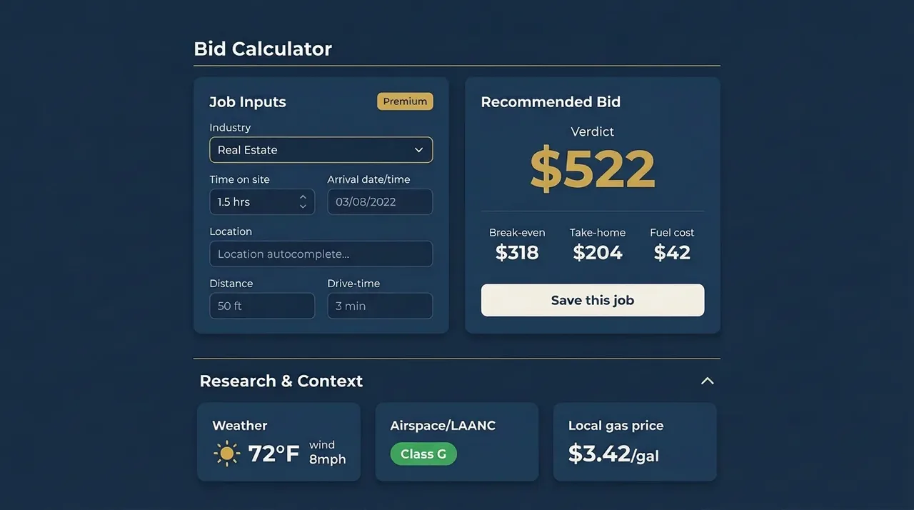
- Research baked in — airspace, weather, drive time, fuel prices
Rotor Rate for the Absolute Newb
A friendly, pilot-to-pilot walkthrough of the free calculator — what every field means, how to read the result, and how to stop underpricing before you even start.
Built-in research tools
- Distance automationGoogle Maps drive time & mileage
- LAANC airspace checkOne-click handoff to Aloft
- Mission-day weatherHour-by-hour forecast for your site
Your complete drone business platform
From the first quote to the final tax deduction, every tool you need to run a profitable drone operation.
Fair-pricing calculator
Drive time, flying time, fuel, and out-of-pocket — all your costs rolled into a defendable number.
Flat-rate verdict
Paste any offer and see if it clears your break-even. Take it, negotiate, or walk.
Specialty deliverables priced
Photo, mapping, inspection, energy, agriculture, plus 3D modeling, LiDAR, BIM/Revit, and digital twin work — each with its own post-processing rate band.
Real take-home
Platform and processor fees baked in — the number you see is the number that hits your bank.
Run your drone operation like a business
Follow each job through awarded, in-work, and completed — with mileage and profit tallied for you along the way.
Mission tracking
Move jobs from pending → awarded → completed in one click. Same-day chains, recurring series, and Refly trips all stay linked to the original mission.
Auto mileage logging
Every awarded mission writes a mileage row at the IRS rate. Reflies and chained drives are captured too — so your deduction matches what you actually drove.
Bottom-line reporting
Real take-home per mission, rolled up into monthly and quarterly tax estimates.
Drone services pricing
How much should you charge?
Real 2026 rate ranges by service line, plus the math that turns them into a defensible price.
- How much should I charge for drone services?
- Most Part 107 pilots charge $150–$500 for residential real estate, $300–$1,500 for commercial or inspection work, and $1,500+ per day for film and event coverage. Rotor Rate's calculator turns your equipment, overhead, drive time, and margin into a defensible price in under a minute. Open the free pricing calculator
- How much should I charge for drone photography?
- $150–$400 for residential real estate (10–20 stills + optional video), $400–$1,200 for commercial or luxury real estate, and $1,000–$3,500 per half-day for brand or commercial photography. Editing time, turnaround, and licensing are the three line items that most often get under-quoted. Free photography pricing calculator
- How much should I charge for drone mapping per acre?
- $10–$30 per acre on small RGB sites (under 100 acres), $5–$15 per acre on mid-size sites, and $3–$8 per acre on 500+ acre sites. Multispectral, thermal, and LiDAR carry a 1.5–4× multiplier. Always set a minimum (typically $400–$800) so small sites stay profitable. Price a mapping job — free calculator
- How much should I charge for a drone inspection?
- $300–$800 for a residential roof, $500–$1,500 for a single tower or commercial roof, and $2,000–$8,000+ per day for industrial work that includes formal reporting. Thermal imagery, RTK accuracy, and report deliverables each warrant a meaningful surcharge. Price an inspection — free calculator
- How much should I charge for 3D modeling, LiDAR, or digital twin work?
- Photogrammetry meshes typically run $1,500–$3,000 per structure, Matterport/NavVis digital twins $2,000–$5,000 per site, scan-to-BIM/Revit handoffs $3,000–$8,000, and survey-grade LiDAR reality capture $2,500–$6,000+ per mission. These deliverables carry higher fly rates ($225–$275/hr) and longer post-processing time (5–10 hrs at $200–$235/hr) than standard photo or mapping work. Rotor Rate's modeling sub-types prefill the typical hours and apply the LiDAR payload multiplier automatically. Try a modeling sample in the calculator
- Should I price drone services hourly or flat-rate?
- Flat-rate when you've done the job before and can predict total time within ~20%. Hourly or day-rate when scope is uncertain. Always set a minimum so short callouts stay profitable — Rotor Rate handles both modes and flags when a flat offer leaves you under your loaded hourly cost. Compare hourly vs. flat in the free calculator
- Is the Rotor Rate calculator free?
- Yes — our full pricing and flat-rate calculators are free at /calculator with no signup required. Includes drive-distance lookups, weather, fuel prices, LAANC airspace checks, an industry rate-suggester, and a regional cost-of-living adjustment from your home-base ZIP. Saving jobs, building a rate library, AI pricing coaching, mission management, and business dashboards are part of the paid plan, with a free trial. Open the free calculator